VOLUME 16 (Supplement)

SciEnggJ 16 (Supplement) 018-026
available online: May 21, 2023
*Corresponding author
Email Address: mabacabac1@up.edu.ph
Date received: September 15, 2022
Date revised: March 30, 2023
Date accepted: April 06, 2023
DOI: https://doi.org/10.54645/202316SupQOO-75
ARTICLE
Mapping coral reef habitats of Apo Reef Natural Park, Sablayan, Occidental Mindoro, Philippines
University of the Philippines, Los Baños
2Museum of Natural History, University of the Philippines, Los Baños
3School of Environmental Science and Management,
University of the Philippines, Los Baños
4Apo Reef Natural Park - Protected Area Management Office,
Department of Environment and Natural Resources
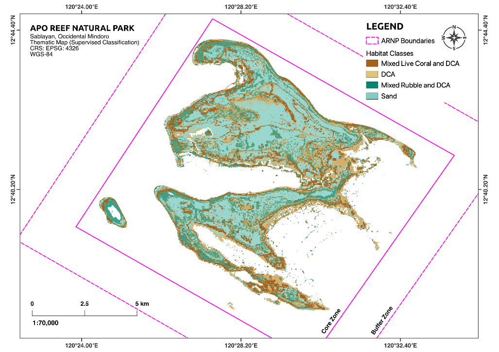
Limited spatial information on Philippine oceanic coral reef resources poses a challenge to conservation and management. In the face of an increased occurrence of natural disturbances, repetitive, broad-scale spatial information is critical in determining large-scale patterns that help managers resolve the potential trajectory of the coral reef ecosystems, elucidating whether it will recover or continue to decline. In this study, we provide a decent habitat map of Apo Reef Natural Park using freely available Sentinel-2 data using the Google Earth Engine (GEE) cloud computing platform. Through the use of training and validation data, we implemented supervised classification via the classification and regression trees (CART) algorithm. The results successfully delineated four major habitat classes across ARNP with an acceptable level of accuracy (58.8%). These habitat classes are: Mixed Live Coral and DCA habitat, DCA habitat, Mixed Rubble and DCA habitat, and Sand habitat. In total, we mapped over 6,000 hectares of shallow subtidal habitats across a 27,000-hectare protected area. Among the classes, sand-dominated habitats had the largest coverage in the shallow subtidal section of the reef complex. The total hard coralline substrate was estimated to cover over 3,800 hectares. The impact of consecutive, high-intensity disturbances that hit ARNP resulted in the predominance of algae-covered habitat types, which in turn resulted in relatively high classification errors of DCA habitats, and Mixed Live Coral and DCA habitats. It is expected that as the reef recovers, accuracy in discerning these habitat types will eventually increase. The study shows the utility of the GEE platform in conducting low-cost, broad-scale monitoring of oceanic reef complexes at a resolution that is acceptable for management purposes.
© 2026 SciEnggJ
Philippine-American Academy of Science and Engineering